Active Pacific storm season brings Super Typhoon In-fa and extratropical transition of Champi
NASA reports elevated tropical cyclone activity in the Northwest Pacific throughout 2026, linked to strong El Niño conditions.
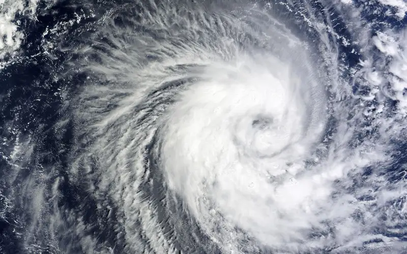 Photo: google
A season of elevated activity
The Northwest Pacific Basin has experienced a period of heightened tropical cyclone activity since April 2026, according to NASA. Following the emergence of Super Typhoon Sinlaku, which impacted Micronesia, Guam, and the Northern Mariana Islands, the region has seen 25 named storms. By late October 2026, the basin remained highly active, with NASA’s Earth Polychromatic Imaging Camera (EPIC) on the DSCOVR satellite capturing images of Super Typhoon In-fa near the Mariana Islands on October 29.
Characteristics of Super Typhoon In-fa
Super Typhoon In-fa was identified as an annular storm, a rare subset of tropical cyclones that account for approximately 4 percent of such storms in the western North Pacific. According to NASA, these storms are characterized by a nearly circular shape and an unusually large eye, often lacking the prominent outer spiral rainbands typical of standard cyclones. Meteorologists sometimes refer to these systems as "doughnuts" or "truck tires." While standard tropical cyclone eyes average 25 kilometers in diameter, annular storm eyes typically measure around 45 kilometers.
The transition of Typhoon Champi
As In-fa churned near the Mariana Islands, the remnants of Typhoon Champi underwent an extratropical transition while moving toward the Bering Sea. NASA meteorologist Gary Partyka explained that while tropical cyclones are warm-core systems fueled by ocean heat, extratropical cyclones possess cold cores and derive energy from temperature contrasts between air masses. These systems often develop fronts and comma-shaped cloud patterns. Partyka noted that while a midlatitude storm likely would have existed over the Bering Sea regardless, Champi’s remnants appeared to intertwine with and intensify the system.
Impacts on Alaska
Champi’s transition followed a significant path through the West Pacific, where it reached maximum sustained winds of nearly 300 kilometers per hour. The storm caused damage in Taiwan, Guam, Japan, and China. Upon reaching Alaska, the remnants brought high winds and precipitation, including both rain and snow. Although some areas experienced these conditions, the state avoided the level of catastrophic damage seen during the 2025 arrival of ex-typhoon Halong, according to news reports cited by NASA.
Historical context and climate factors
Rick Thoman, a meteorologist and climatologist at the University of Alaska Fairbanks, identified Champi as the fourth ex-typhoon to enter Alaskan waters in 2026, following Bang-Lang, Dujuan, and Choi-wan. Thoman noted that approximately 60 ex-typhoons have affected Alaska since 1970. The frequency of such events in 2026 is comparable to the autumns of 1997 and 2015, both of which were strong El Niño years and saw three ex-typhoons each.
The role of El Niño
NASA reports that 2026 has been a particularly active year for Pacific tropical cyclones, with the current strong El Niño identified as a likely contributor. El Niño, a climate pattern occurring every two to seven years, involves warmer-than-normal water temperatures in the equatorial Pacific. Experts suggest this phenomenon influences storm tracks in the Northwest Pacific, causing systems to curve northward toward Guam, the Northern Mariana Islands, Japan, and the Korean Peninsula rather than continuing westward toward East and Southeast Asia.
Wind field expansion
A key feature of the extratropical transition process is the expansion of a storm's wind field. Gary Partyka of NASA’s Goddard Space Flight Center clarified that this does not necessarily mean the winds become stronger, but rather that they cover a significantly larger geographic area. This expansion is considered a hallmark of the transition from a tropical to an extratropical system, as observed during the movement of Champi’s remnants into the Bering Sea's storm track.
This story was prepared with AI assistance from the sources listed below and reviewed by our editors.
Sources
Related stories

Record Carbon Dioxide Levels Reached in 2025, WMO Reports
The World Meteorological Organization (WMO) announced on Tuesday that atmospheric levels of carbon dioxide (CO2) and other significant greenhouse gases, resulting from fossil fuel combustion, hit unprecedented highs in 2025, contributing to increased long-term global warming.